This list is a work-in-progress.
We have identified software and hardware projects that are relevant to satellite communications.
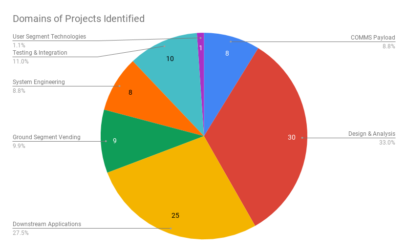
| Name | Description | Category Software/Hardware/Specifications | License | Specificity | Type | Domain (ST 1.2) | Link | Format | Type of maintaining entity |
| ARAMIS | Ionospheric Scintillation Monitor receiver. Digitized IF signal, various error models, bit true simulation. Requires a front end from IP-Solutions | Hardware & Software | Free for academic use | Position and Navigation | Downstream Applications | http://www.ip-solutions.jp/ionosphere_scintillation_monitor.html | Executable in windows | ||
| Capella MBSE | MBSE modeling tool – used by a number of satellite industries (TAS, EUMETSAT, …) | Software | EPL-1.0 | Generic | Sat Comm | Design & Analysis | https://www.polarsys.org/capella/ | ? | Foundation |
| GMAT | General mission analysis tool | Software | Apache License 2.0 | Specific Spatial | Mission analysis/planning | Design & Analysis | http://gmatcentral.org/ | Non-ESA Space Agency > US | |
| GNU Radio | Generic Software Defined Radio platfrorm | Software | GPL-3.0 | Generic | Simulation / Real time operation | Testing & Integration | http://gnuradio.org/ | Community | |
| libcsp | small protocol stack written in C. CSP is designed to ease communication between distributed embedded systems in smaller networks, such as Cubesats. The design follows the TCP/IP model and includes a transport protocol, a routing protocol and several MAC-layer interfaces | Software | LGPL-2.1 | Specific Spatial | Sat Comm | COMMS Payload | http://www.libcsp.org | Source code | Community |
| LibreCube | Reference design for cubesats | Hardware & Software & Specifications | Various | Specific Spatial | Reference design | System Engineering | https://librecube.org/ | Community | |
| Network Simulator 3 (ns-3) | ns-3 is a discrete-event network simulator for Internet systems, targeted primarily for research and educational use. ns-3 is free software, licensed under the GNU GPLv2 license, and is publicly available for research, development, and use | Software | GPL-2.0 | Generic | Sat Comm | Design & Analysis | https://www.nsnam.org | Source code | Academia > US |
| ngSpice | Mixed-circuit simulator | Software | BSD-3-Clause | Generic | Simulation | Design & Analysis | http://ngspice.sourceforge.net/ | Academia > US | |
| OCDT | Concurrent Engineering Tool (Open source but needs registering) | Software | ESA community open source software licence | Specific Spatial | Design | System Engineering | https://ocdt.esa.int/login?back_url=https%3A%2F%2Focdt.esa.int%2F | ESA | |
| OpenAMIP | OpenAMIP is an IP based protocol that facilitates the exchange of information between an Antenna Controller Unit and a satellite. | Specifications | couldn’t find any license info | Specific Spatial > Sat Comm | Sat Comm | Ground Segment Vending | https://www.linksystems-uk.com/openamip/ | ? | SMB > US |
| OpenBach | a modular benchmark allowing for fast integration of metrology tools over different types of networks and equipments | Software | GPL-3.0 | Specific Spatial > Sat Comm | Sat Comm | Design & Analysis | http://www.openbach.org | Source Code | ESA Member > FR |
| OpenEMS | EM field simulation | Software | GPL-3.0+ | Generic | Simulation | Design & Analysis | http://www.opensourceimaging.org/project/open-ems-a-free-and-open-electromagnetic-field-solver/ | ||
| OpenSAND | Emulate an end-to-end satellite communication system | Software | GPL-3 .0 OR LGPL-3.0 | Specific Spatial > Sat Comm | Simulation | Design & Analysis | http://opensand.org/content/home.php | ESA Member > FR | |
| Orekit | Space flight dynamics library/framework | Software | Apache-2.0 | Specific Spatial | Mission analysis/planning | Design & Analysis | https://www.orekit.org/ | Corp > FR | |
| PEPSAL | TCP PEP emulator for satellite gateways | Software | GPL-2.0 | Specific Spatial | Sat Comm | Design & Analysis | https://github.com/danielinux/pepsal | Source Code | |
| Poliastro | Astrodynamics and Orbital Mechanics solver/simulator | Software | MIT | Specific Spatial | Simulation | Design & Analysis | https://github.com/poliastro/poliastro | y | |
| Qucs | Circuit Simulator | Software | GPL-2.0 | Simulation | Design & Analysis | http://qucs.sourceforge.net/ | |||
| Satellite Network Simulator (SNS3) | Satellite Network Simulator 3 (SNS3) is a satellite network extension to Network Simulator 3 (ns-3) platform | Software | GPL-2.0 | Sat Comm | Design & Analysis | http://satellite-ns3.com | Source code available upon request | ||
| SatNOGS | Ground station global network | Hardware & Software & Data | AGPL-3.0 | Specific Spatial > Sat Comm | Ground segment | Ground Segment Vending | https://satnogs.org | Foundation > GR | |
| Skyfield | Astronomical computations library | Software | MIT | Library | Design & Analysis | https://rhodesmill.org/skyfield/ | Individual | ||
| srsLTE | srsLTE is a free and open-source LTE software suite developed by SRS (www.softwareradiosystems.com). It includes srsUE, srsENB, srsEPC. It uses software from the OpenLTE project . | Software | AGPL-3.0 OR Proprietary | Generic | Sat Comm | COMMS Payload | https://www.softwareradiosystems.com/ | Source Code and Debian packages | SMB > IE |
| SPELL | SPELL is a free Open Source software package composed of an integrated environment for the development and execution of satellite automated procedures. It is capable of running any procedure via different Ground Control System and for any spacecraft. | Software | GPL-3.0 AND LGPL-3.0 AND EPL-1.0 | Sat Comm | System Engineering | https://sourceforge.net/p/spell-sat/wiki/Home/ | Source code | SMB > LU | |
| xnec2c | Antenna simulation | Software | GPL-3.0 | Simulation | COMMS Payload | https://www.qsl.net/5/5b4az//pkg/nec2/xnec2c/doc/xnec2c.html | Individual | ||
| ROHC | ROHC library provides a way to reduce the bandwidth usage on network links with limited capacity or expensive costs. | Software | LGPL-2.1+ | Specific Spatial > Sat Comm | Sat Comm | Ground Segment Vending | https://rohc-lib.org/ | ESA Member > FR | |
| LimeSDR | LimeSDR is a low cost, open source software defined radio (SDR) platform that can be used to support just about any type of wireless communication standard. | Hardware | CC-BY-3.0 AND Apache-2.0 | Sat Comm | Ground Segment Vending | https://limemicro.com/products/boards/limesdr/ | SMB > UK | ||
| HackRF | a low cost, open source Software Defined Radio platform. | Hardware & Software | GPL-2.0+ | Generic | Sat Comm | Ground Segment Vending | https://github.com/mossmann/hackrf | ||
| Elmer | Multiphysical simulation software | Software | GPL-2.0 AND LGPL-2.1 | Generic | Simulation | Design & Analysis | https://www.csc.fi/web/elmer | Fortran | SMB > FI |
| FreeCAD | CAD | Software | LGPL-2.0+ | Generic | Design | Design & Analysis | https://www.freecadweb.org/ | ||
| GDAL | GDAL is a translator library for raster and vector geospatial data formats. As a library, it presents a single raster abstract data model and single vector abstract data model to the calling application for all supported formats. | Software | MIT | Specific Spatial > Earth Obsevation | Downstream Applications | https://gdal.org/ | Source and binaries for Windows, Debian and containers | Foundation | |
| GeoJSON | GeoJSON is a format for encoding a variety of geographic data structures. | Specifications | Free | Generic | Downstream Applications | https://geojson.org/ | Format | Foundation | |
| GeoServer | GeoServer is an open source software server written in Java that allows users to share and edit geospatial data. Designed for interoperability, it publishes data from any major spatial data source using open standards: WMS, WFS, WCS, WPS and REST | Software | GPL-2.0 | Generic | Earth Observation | Downstream Applications | http://geoserver.org | Supports WFS, WMS and WCS standards | Community |
| Gpredict | Satellite tracking | Software | GPL-2.0 | Specific Spatial | Mission analysis, operations | Ground Segment Vending | http://gpredict.oz9aec.net/ | Individual > DK | |
| GPS-SDR-SIM | GPS-SDR-SIM generates GPS baseband signal data streams, which can be converted to RF using software-defined radio (SDR) platforms, such as ADALM-Pluto, bladeRF, HackRF, and USRP. | Software | MIT | Specific Spatial > Position and Navigation | Position and Navigation | Testing & Integration | https://github.com/osqzss/gps-sdr-sim | Source code | Individual > JP |
| gvSIG Desktop | gvSig Desktop is easy to work in a variety of formats, vector and raster files, databases and remote services. Interoperable: able to work with most known data formats. | Software | GPL-2.0 | Generic | Earth Observation | Downstream Applications | http://www.gvsig.com/en | Platforms: Linux / Unix, macOSX, Windows, Android. Languages: Java, Python, Groovy, Renjin, Scala | Community |
| JAG3D (Java Applied Geodesy 3D) | JAG3D is one of the most popular open source least-squares software package for geodetic sciences. It is designed to combine hybrid terrestrial observations like leveling, directions, distances or vertical angles in a uniform and rigorous mathematical model. | Software | GPL-3.0 | Generic | Position and Navigation | Downstream Applications | https://software.applied-geodesy.org/en/ | Java | SMB > DE |
| Julia Astrodynamics | Astrodynamics and Orbital Mechanics solver/simulator | Software | MPL-2.0 | Specific Spatial | Simulation | Design & Analysis | https://github.com/JuliaAstrodynamics/Astrodynamics.jl | Individual > DE | |
| KiCAD | EDA | Software | GPL-3.0+ | Generic | Design | Design & Analysis | http://kicad-pcb.org/ | Community | |
| KubOS | A set of open source tools for smallsat missions and operations | Software | Apache-2.0 | Specific Spatial | Sat Comm | System Engineering | https://www.kubos.com/ | ? | SMB > US |
| Leandvb | Leandvb is a lightweight implementation of portions of the DVB-S and DVB-S2 standards in plain C++. It is developed primarily for receiving Digital Amateur TV from the ISS and from the QO-100 geostationary transponder. | Software | GPL-3.0+ | Specific Spatial > Sat Comm | Sat Comm | Testing & Integration | http://www.pabr.org/radio/leandvb/leandvb.en.html | Executable code | Individual > FR |
| LuaRadio | lightweight, embeddable flow graph signal processing framework for software-defined radio. | Software | MIT | Generic | Sat Comm | Testing & Integration | http://luaradio.io | Individual > US | |
| Equinox | C++11 based SDR platform targeting applications where real-time execution and resources utilization is the primary concern | Software | GPL-3.0 | Generic | Sat Comm | Testing & Integration | https://gitlab.com/equinox-sdr | Individual | |
| AFF3ct | simulator and a library dedicated to the Forward Error Correction (FEC or channel coding). | Software | MIT | Generic | Sat Comm | Testing & Integration | https://aff3ct.github.io/ | Source code | Academia > FR |
| MEEP | Electromagnetics Simulation | Software | GPL-2.0+ | Generic | Simulation | Design & Analysis | https://meep.readthedocs.io/en/latest/ | SMB | |
| Octave | Scientific programming language | Software | GPLv3 | Generic | Simulation | Design & Analysis | https://www.gnu.org/software/octave/ | ||
| Open Data Cube | Open Data Cube Core provides an integrated gridded data analysis environment for decades of analysis ready earth observation satellite and related data from multiple satellite and other acquisition systems. | Software | Apache License 2.0 | Specific Spatial > Earth Obsevation | Earth Observation | Downstream Applications | https://github.com/opendatacube/datacube-core | Collection of software base on Python library | Community |
| OpenAstro | Astrodynamics and Orbital Mechanics solver/simulator | Software | MIT | Specific Spatial | Simulation | Design & Analysis | https://github.com/openastro/astro | ||
| OpenMCT | Open MCT is a next-generation mission operations data visualization framework. Web-based, for desktop and mobile. | Software | Apache-2.0 | Specific Spatial | Sat Comm | System Engineering | https://nasa.github.io/openmct/ | Non-ESA Space Agency > NASA | |
| Orfeo ToolBox (OTB) | Orfeo ToolBox (OTB) is an open-source project for state-of-the-art remote sensing. Built on the shoulders of the open-source geospatial community, it can process high resolution optical, multispectral and radar images at the terabyte scale. | Software | Apache-2.0 | Specific Spatial > Earth Obsevation | Earth Observation | Downstream Applications | https://www.orfeo-toolbox.org | Source and Executable (Linux, Windows, macOS) | ESA Member > FR |
| Pandas | High-performance, easy-to-use data structures and data analysis tools | Software | BSD | Generic | Library | Design & Analysis | https://pandas.pydata.org/ | struggling to find email | |
| PyEphem | Astronomical computations library | Software | GNU Library or Lesser General Public License (LGPL) (LGPL) | Library | Design & Analysis | https://rhodesmill.org/pyephem/ | |||
| SciDB Community Edition | Paradigm4’s SciDB is a scalable, scientific database management system that helps researchers integrate and analyze multiple lines of evidence—like genomic, clinical, images, RWE, and sensor data—all in one analytical platform. | Software | GPL-3.0 | Generic | Downstream Applications | https://www.paradigm4.com/try_scidb/ | Software that can run on existing hardware or in the cloud. | ||
| SciPy | Scientific computing library for python | Software | BSD | Generic | Library | Design & Analysis | https://www.scipy.org/ | ||
| Theano | Theano is a Python library that allows you to define, optimize, and evaluate mathematical expressions involving multi-dimensional arrays efficiently. | Software | BSD-3-Clause | Generic | Design & Analysis | https://github.com/Theano/ | Python library | ||
| Whitebox GAT – Geospatial Analysis Tools | Open-source desktop GIS and remote sensing software package for general applications of geospatial analysis and data visualization. | Software | GPL-3.0 | Generic | Earth Observation | Downstream Applications | http://www.uoguelph.ca/~hydrogeo/Whitebox/index.html | Executable (Windows, Linux, macOS) | |
| Celestlab | CelestLab is a Scilab toolbox for Space Flight Dynamics. | Software | CECILL-2.0 | Specific Spatial | Mission analysis | Design & Analysis | https://atoms.scilab.org/toolboxes/celestlab | ESA Member > FR | |
| ADAM API Toolkit | Calculates BRDFs for any combination of viewing and illumination geometry from normalized MODIS surface reflectance product (land) and for SeaWifs and QuickScat observations (ocean). Monthly means with a resolution of 0.1×0.1 degree, 1 nm from 300 – 4000 nm. | Software | Free online service after registration | Earth Observation | Downstream Applications | http://adam.noveltis.fr/ | Executable online | ||
| AHN-viewer | Provides a file with detailed and accurate altitude data for the whole of the Netherlands (DEM data) | Software | Free online service | Earth Observation | Downstream Applications | https://ahn.arcgisonline.nl/ahnviewer/ | Executable online | ||
| Android Raw GNSS Measurement | Set of tools to log raw GNSS measurements on Android devices and analyse them on Linux, Windows, macOS | Software | Apache v2 | Position and Navigation | Downstream Applications | https://developer.android.com/guide/topics/sensors/gnss | GnssLogger source code in Matlab, but you don’t need Matlab to use it | ||
| ESA Online Dissemination | Applet Earth Observation metadata visualization tool | On line Service | LGPL | Specific Spatial > Earth Obsevation | Earth Observation | Downstream Applications | https://esar-ds.eo.esa.int/oads/access/ | Java | |
| GMSEC API | The goal of GMSEC is to provide a rapid, flexible, and cost-effective means to fulfill a variety of mission concepts, including concepts not yet fully developed. | Software | NASA-1.1+ | Specific Spatial | Sat Comm | System Engineering | https://opensource.gsfc.nasa.gov/projects/GMSEC_API_30/index.php | Non-ESA Space Agency > NASA | |
| GNSS-SDR | GNSS-SDR is an open source project that implements a global navigation satellite system software defined receiver in C++. With GNSS-SDR, users can build a GNSS software receiver by creating a graph where the nodes are signal processing blocks and the lines represent the data flow between them | Software | GPL-3.0 | Specific Spatial > Position and Navigation | Position and Navigation | Design & Analysis | http://gnss-sdr.org | Source code and libs for Linux Debian, macOS. Runs on GNU Radio | Academia > ES |
| GNSS-SDRLIB | Open Source GNSS SDR Library | Software | GPL-2.0+ | Specific Spatial > Position and Navigation | Position and Navigation | Downstream Applications | https://github.com/taroz/GNSS-SDRLIB | Source and Executable for Windows | Individual > JP |
| goGPS | goGPS is a software package designed to improve the positioning accuracy of low-cost (single-frequency) GPS devices by RTK technique and with the aid of a DTM. Currently it requires raw data (observations) at 1 Hz in input. Package designed to perform GNSS static positioning in post-processing, PPP adn NET. | Software | GPL-3.0 | Specific Spatial > Position and Navigation | Position and Navigation | Testing & Integration | http://www.gogps-project.org | Source code for Matlab 2016a+ and Java | Academia > IT |
| GPSTk | The goal of the GPSTk project is to provide an open source library and suite of applications to the satellite navigation community–to free researchers to focus on research, not lower level coding. | Software | LGPL-3.0 | Specific Spatial > Position and Navigation | Position and Navigation | User Segment Technologies | https://github.com/SGL-UT/GPSTk | Source and Executable (Unix, Windows, macOS) | Academia > US |
| GRASS GIS – Geographic Resources Analysis Support System | Geographic Resources Analysis Support System, commonly referred to as GRASS GIS, is a Geographic Information System (GIS) used for data management, image processing, graphics production, spatial modelling, and visualization of many types of data. | Software | GPL-2.0 | Generic | Earth Observation | Downstream Applications | https://grass.osgeo.org | Stand-alone application or backend for other software packages | Community |
| MACCS/MAJA | MACCS (Multi-sensor Atmospheric Correction and Cloud Screening) is a level 2A processor, which detects the clouds and their shadows, and estimates aerosol optical thickness (AOT), water vapour and corrects for the atmospheric effects. | Software | Apache v2.0 | Specific Spatial > Earth Obsevation | Earth Observation | Downstream Applications | https://gitlab.orfeo-toolbox.org/maja/maja | Language: C++, Python and Cmake. OS:Linux RedHat 6+, CENTOS 6+ Ubuntu 12.04+ | ESA Member > FR |
| OGC | The Open Geospatial Consortium (OGC) is an international not for profit organization committed to making quality open standards for the global geospatial community. These standards are made through a consensus process and are freely available for anyone to use to improve sharing of the world’s geospatial data. In here we can find the WMS (Web Map Service), WPS (Web Processing Service Interface Standard), CSW (Catalog Service for the Web). | Specifications | Free | Generic | Downstream Applications | http://www.opengeospatial.org/ | Standards | ||
| Open Layers | OpenLayers makes it easy to put a dynamic map in any web page. It can display map tiles, vector data and markers loaded from any source. OpenLayers has been developed to further the use of geographic information of all kinds. | Software | BSD-2-Clause-FreeBSD | Generic | Earth Observation | Downstream Applications | https://openlayers.org/ | API and codes | |
| Open Street Map | OpenStreetMap (OSM) is a collaborative project to create a free editable map of the world. | Data | OdbL-1.0 | Generic | Earth Observation | Downstream Applications | https://wiki.openstreetmap.org/wiki/Main_Page | Data online | Community |
| OpenAir Interface | 5G/4G Emulation Software | Software | OAI Public License 1.1, Apache-2.0 | Generic | Simulation | Design & Analysis | https://www.openairinterface.org/ | Academia > FR | |
| PolSARpro | Provide a tool for self-education in the field of polarimetric SAR data analysis and a comprehensive suite of functions for the scientific exploitation of fully and partially polarimetric data and the development of applications for such data | Software | GPL-2.0 | Specific Spatial > Earth Obsevation | Earth Observation | Design & Analysis | https://earth.esa.int/web/polsarpro | Executable for Windows and Linux | |
| QGIS | Desktop application to create, edit, visualise, analyse and publish geospatial information. | Software | GPL-2.0 | Generic | Earth Observation | Downstream Applications | https://qgis.org/en/site/ | Linux, Unix, macOS and Windows | |
| RTKLIB | Open Source Program Package for GNSS Positioning (SDR) | Software | BSD 2 | Specific Spatial > Position and Navigation | Position and Navigation | Testing & Integration | http://www.rtklib.com | Source and Executable for Windows | |
| SAGA – System for automated Geoscientific Analyses | GIS software, has been deigned for an easy and effecrive implementation of spatial algorithms, offers a comprehensive, growing set of geoscientific methods, provides an easily approachable user interface with many visualisation options. | Software | GPL-2.0 | Earth Observation | Downstream Applications | http://www.saga-gis.org/en/index.html | Coded in C++. Source code and GUI executable for Windows and Linux | ||
| Sen2Agri system | ESA Online Dissemination | Software | GPL-3.0 | Specific Spatial > Earth Obsevation | Earth Observation | http://www.esa-sen2agri.org/operational-system/system-download/ | Linux | ESA | |
| SNAP and Sentinel Toolboxes | The ESA toolboxes support the scientific exploitation for the ERS-ENVISAT missions, the Sentinels 1/2/3 missions and a range of National and Third Party missions. The three toolboxes are called respectively Sentinel 1, 2 and 3 Toolboxes and share a common architecture called SNAP. They contain some functionalities of historical toolboxes such as BEAM, NEST and Orfeo Toolbox that were developed over the last years. | Software | GPL-3.0 | Specific Spatial > Earth Obsevation | Earth Observation | http://step.esa.int/main/download/ | Source and Executable (Windows, macOS, Unix) | ESA | |
| TauDEM – Terrain Analysis Using Digital Elevation Models | TauDEM is a suite of Digital Elevation Model (DEM) tools for the extraction and analysis of hydrologic information from topography as represented by a DEM | Software | GPL-3.0 | Generic | Earth Observation | Downstream Applications | http://hydrology.usu.edu/taudem/taudem5/index.html | Source code, command line executable and ArcGIS toolbox GUI | |
| Viking GPS data editor and analyzer | Viking is a free/open source program to manage GPS data. You can import, plot and create tracks, routes and waypoints, show OSM, Bing Aerial and other maps, geotag images, see real-time GPS position (not in Windows), make maps using Mapnik (not in Windows), control items, etc. | Software | GPL-2.0 | Earth Observation | Downstream Applications | https://sourceforge.net/projects/viking/ | Executable (written mostly in C) |